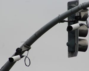
License plate readers on Northbound Fremont Boulevard
According to data from the Northern California Regional Intelligence Center (NCRIC), the city of Fremont collected 14.5 million license plates and photos from license plate readers located throughout the city from December 2016 to October 2017.
The installation of stationary license plate readers was approved by the Fremont City Council on July 14, 2015, without any public comment or discussion during the meeting.
Of the 28 jurisdictions sending license plate reader data to NCRIC, Fremont collects the third-highest amount of data, behind Vallejo (21.7 million) and Piedmont (21.3 million). NCRIC is a regional fusion center that provides a license plate database where agencies can send their collected data. Other agencies, including the IRS, Department of Homeland Security, FBI, National Park Service, California Department of Insurance and others can access this database and search for license plate data.
The license plate reader on westbound Stevenson Boulevard near the entrance to northbound Interstate 880 generates the most data, collecting an average of 14,736 license plates and photographs each day during October 2017.
Although similar statistics are not available for Fremont, analysis of license plate reader data from other jurisdictions has found that 99.7% of the data collected by license plate readers is of people not suspected of or charged with any crime. For Fremont, that means 14,519,834 of the 14,563,525 photos and license plates collected during an 11-month period was of innocent people.
Click here for a map showing license plate reader locations and links to Google Street View images:
Eastbound Auto Mall Parkway at Christy (1): Google Street View
Westbound Mowry Avenue at entrance to Northbound 880 (1): Google Street View
Westbound Decoto Road at entrance to Northbound 880 (1): Google Street View
Southbound Ardenwood Boulevard to Westbound 84 (1): Google Street View
Westbound Stevenson Boulevard at entrance to Northbound 880 (1): Google Street View
Northbound Mission Boulevard at Washington Blvd (1): Google Street View
Southbound Mission Boulevard at Paseo Padre Parkway (2): Google Street View
Northbound Fremont Boulevard at Enea Terrace (2): Google Street View
Camera operated by Pacific Commons Shopping Center at Northbound Christy Street south of Auto Mall Parkway (1): Google Street View
Source documents:
NCRIC ALPR data from December 2016 to October 2017
NCRIC ALPR data from October 2017 to July 2018